Recording and tracks
Start and stop a recording, run a daily track, take photos, organise routes in folders, import and export GPX/KML/KMZ, and share a track.
DirtMap records where you have been in two ways: Track recording captures one route and saves it with your routes, while Daily Recordings logs a whole day in the background, with photos and a 3D replay at the end. This page walks through starting and stopping both, managing saved tracks (folders, rename, delete), importing and exporting GPX/KML/KMZ, and sharing. Every step describes the phone app; where the web version or the car screen differs, it is called out.
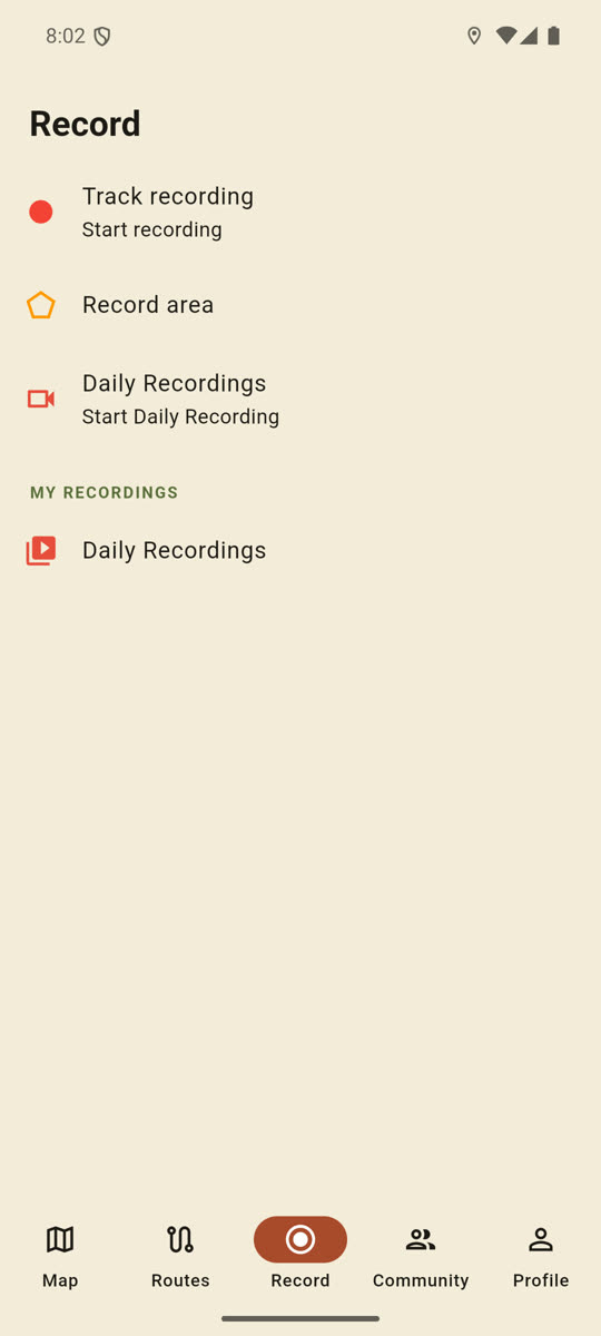
Track recording (the classic recording)
- In the bottom bar, tap the Record tab.
- Tap Track recording (subtitle: Start recording).
- The app switches back to the Map tab and shows “Route recording started!”.
- A permanent notification appears in the status bar: Recording route. Do not swipe it away — it is what keeps the recording alive when you leave the app or turn the screen off.
- While recording, a red Stop recording button sits on the right edge of the map. On the Record tab the row now reads Recording….
- When the trip is over, tap the red stop button (or tap Track recording on the Record tab again).
- The track is named automatically as
Track_YYYYMMDD_HHMMand uploaded: “Route saved: …”. You will find it under Routes → My Routes, where you can rename it.
Worth knowing:
- Recording needs location access. If the app has no location permission, the recording will not start.
- The free route quota (see below) is checked when you start the recording, not when it is saved — so you can never lose a full day’s recording to a paywall.
- If you are not signed in, or you have no data connection, the track is saved on the phone and uploads by itself once you are back online.
Recording an area
The Record area row on the same tab captures a closed polygon (a plot, a clearing, a camp). Premium feature. After starting, walk the whole boundary, stop with the orange stop button, give it a name, and find it on the Areas tab. Area recording only runs with the app open — it has no background service behind it.
Daily Recordings
A full-day GPS log: it runs in the background, you can attach photos to it, and it can be played back in 3D afterwards. Premium feature.
- Record tab → Daily Recordings row (subtitle: Start Daily Recording).
- The status bar shows a Daily recording • 0.0 km · 0 min notification, refreshed every ten seconds. Do not swipe this one away either.
- Drive, lock the screen, switch to other apps — the recording keeps going. It stores a point every 5 metres and writes a local backup every 30 seconds.
- To stop: the same row (Stop Recording), or the red stop button on the map. You will see “Uploading…” and then “Daily track saved to cloud.”.
- Finished recordings live under Record → My recordings → Daily Recordings: date, distance, duration, point count.
- Each card carries three actions: 3D replay (Convoy 3D on a day you rode in a convoy), Download GPX, and the bin icon (Delete).
Photos during the trip
While a daily recording runs, a white camera button appears on the map under the stop button.
- Tap the white Take Photo button (the same action also appears on the Record tab while recording).
- Take the picture with the camera.
- You get “Uploading media…” and then “Photo saved to track.”.
- With no signal: “Saved locally — N pending upload”. Nothing is lost; the photo uploads automatically once the network is back.
- Photos pop up in the 3D replay at the spot where they were taken.
Marking a spot without a photo
To simply note a place (a ford, a gate, a camp), long-press the map: the Save place dialog opens, type a name and tap Save. This needs an account. It works offline too: “Offline mode: the place was saved and will sync when you reconnect.” Saved places are on the Places tab of the My Routes panel.
Recovery after the app was killed
If the app crashes mid-recording, the battery dies, or the system restarts, the Unfinished recording dialog appears on the next launch, showing the distance and point count that were captured.
- Resume — picks the recording up exactly where it stopped.
- Save and start new — closes and uploads the unfinished recording.
- Discard — throws the backup away.
The same dialog also appears when a daily recording failed to upload on stop (“Upload failed. Try again.”) — the local backup survives, so on the next launch you can retry with Save and start new.
The Routes tab and the My Routes panel
- In the bottom bar, tap the Routes tab, then My Routes. (On the web: the route icon in the top bar, or ☰ Menu → My Routes.)
- The panel has three tabs: Routes, Places, Areas.
- Along the top is the folder chip bar: All, your own folders, and New folder.
- In the My routes list every row has: an eye icon to show or hide the track on the map, the pencil for Rename, the ⋮ menu for Share / Add to folders / Download GPX, and the red bin for Delete.
- Tapping the name closes the panel and zooms the map to that track.
- The Shared routes section (collapsed by default) holds what other people shared with you. There you can only display them (Show all / Hide all).
- At the bottom of the panel: the GPX Upload button and Close.
Folders
- New folder: the New folder chip → Name, Description (optional), Icon, Color → Save.
- Filter: tap a folder chip and the list shows only the routes in that folder.
- Folder actions: the ⋮ on the chip (or a long press) → Edit folder, Add routes, Share folder, Delete folder.
- In Add routes, tick the tracks (All / None), then tap Add (n).
- You can also file one route from its row: ⋮ → Add to folders → Which folders? → Save. A route can sit in several folders.
- Deleting: Delete folder → “Delete this folder? Tracks inside are kept.” Deleting the folder never deletes the tracks.
Importing GPX, KML and KMZ
- Routes tab → GPX Upload (the same button also sits at the bottom of the My Routes panel).
- Pick the file. Accepted formats:
.gpx,.kml,.kmz. - The Name Route dialog opens — edit the name if you want, then tap Save.
- The app uploads it, draws it highlighted, and zooms to it. If a folder chip was selected, the new route lands in that folder.
- If the file is a closed loop (for example a Gaia-style area), the app offers to save it as an area instead.
- If a KMZ carries a scanned map (a GroundOverlay), it is laid over the map — even when the file contains no track at all.
Downloading and exporting a GPX
- In the My Routes panel, open the track’s ⋮ menu → Download GPX.
- On the phone the system share sheet opens (save to a file, send it in a chat). On the web the browser downloads it; on desktop you get a save dialog.
- For a daily recording, the Download GPX button on the card does the same.
Where an original uploaded GPX exists, the app hands back that exact file — elevation and timestamps are preserved.
Sharing, and what the recipient sees
- Share a track: the row’s ⋮ menu → Share. Share a folder: the folder chip’s ⋮ menu → Share folder.
- By email: type the address, tap Send → “Shared with …”. The recipient sees it in their own My Routes panel, in the Shared routes section, once they sign in with exactly that address. It is view-only: they cannot rename, delete or file it.
- Public link: tap Create public link → the
https://dirtmap.eu/r?t=…address appears. Copy puts it on the clipboard, Send opens the system share sheet. Remove link revokes it. - Whoever opens the link sees a simple web page (in English) listing the routes, with an Open in DirtMap and a Download GPX button.
- If they tap Open in DirtMap with the app installed, the app asks Import shared routes? → Import. It creates a folder named after the share and copies the tracks into it.
- Your own shares are listed under Routes → My shares, grouped as Track shares (n) and Folder shares (n). The bin icon revokes a share.
The free limit: 15 cloud routes
A free account keeps up to 15 of your own routes in the cloud. The app checks this when you start a track recording, when you import a GPX, and when you save from the planner. Once you are at the cap, the Premium feature sheet opens instead of the recording starting.
- Routes shared with you do not count towards the limit.
- If you would rather not subscribe, delete some old tracks — or download them as GPX first and then delete them.
- Daily recording and area survey are premium features in their own right.
Recording from the car screen
- Android Auto: from the map, Menu → Record track toggles the track recording. The line underneath shows the state (“Tap to start” / ”● Recording”).
- CarPlay: the record (●) button in the map button row does the same.
- Both need the phone app running. If it is not, the car screen says: “The phone app isn’t running. Open it to record.”
If something goes wrong
I tap start and nothing happens. There is no location permission. Check in the system settings that DirtMap has location access; for background recording that means “Allow all the time” on Android and “Always” on iPhone.
Recording stops as soon as I pocket the phone. Either you swiped the permanent notification away, or the system’s battery optimisation killed the app. Leave the notification alone and exclude DirtMap from battery optimisation.
“Route too short to save.” The recording has fewer than 2 points or is shorter than 20 metres — the app will not store that.
“Track too short to save (< 2 points).” The same rule on a daily recording.
“Upload failed. Try again.” The daily track did not reach the cloud (no connection, or the connection dropped). The local backup survives: restart the app and pick Save and start new in the Unfinished recording dialog.
“Route saved locally — it will upload automatically when you’re back online.” Not an error: the track is on the phone and goes up on its own once there is a connection. Do not clear the app’s data in the meantime.
“Saved locally — N pending upload” means the same for photos: they wait in a queue and upload automatically when the network returns.
“Log in to save places!” Saving a place needs an account. A guest account is enough.
“Please choose a GPX, KML or KMZ file.” You picked a file with a different extension (a ZIP or a TCX, for instance).
“Couldn’t read any track from this file (GPX / KML / KMZ).” The format is fine, but the file holds no track or route geometry — only waypoints, for example.
“GPX download failed.” The export needs internet, because the original file lives in the cloud. Offline the track still draws on the map; you just cannot export it.
“Couldn’t import the shared routes.” The link was revoked or is malformed, or you are not signed in. Ask for a fresh link, and sign in before importing.
The recipient cannot see an email share. The share is bound to exactly the email address their account was created with. Check the address, and have them reopen the My Routes panel — the Shared routes section is collapsed by default.
I deleted a route but it is still listed under My shares. The share row is not removed together with the track. Open Routes → My shares and revoke it with the bin icon.
I deleted a folder and my routes are gone. They are not: deleting a folder only removes the filing. Tap the All chip and they are all back.