Getting started
Account or guest sign-in, location permission, the parts of the map screen, language, and day/night appearance.
This page covers the first five minutes: how to get into the app, what you have to allow, and what everything on the map screen is. Once you have done this, every other feature — recording a track, convoys, competitions — is reachable from the same five tabs.
It describes the phone app (Android and iOS). The web version (dirtmap.eu in a browser) is laid out differently: no bottom tab bar there, but a top bar and a side menu.
1. Create an account
- Start the app. After the logo you land on the sign-in screen: the header reads Welcome back!, below it Log in to continue.
- Scroll to the bottom of the screen and tap Don’t have an account? Register here!
- On the Create new account screen fill in all three fields:
- Display Name — this is what others see in convoys and in competition standings.
- Email address
- Password — at least 8 characters; anything shorter is rejected.
- Tap the Registration button.
- On success you get Successful registration! and the app takes you straight to the map — no separate sign-in step.
- An orange bar appears at the top of the map: Please verify your email address! Open the email you received and click the link in it. If it never arrived, tap Resend in that bar.
2. Log in with an existing account
- On the sign-in screen fill in Email address and Password.
- Tap Login. The app opens the map.
Forgotten password
- Tap Forgot password? on the right.
- In the Reset password dialog enter the email address of your account.
- Tap Send reset link.
- You get: “If that address has an account, a reset link is on its way. Check your inbox.” The link in the email lets you set a new password.
3. Guest mode — getting in without an account
If somebody is only joining your tour or your competition, they do not have to register. A guest gets a real user id, so they show up in the convoy and on the leaderboard exactly like anyone else.
- On the sign-in screen, below the or divider, tap Try it without an account.
- In the Pick a nickname dialog type a name into the Display Name field. You can leave it empty — the app then assigns one (for example “Guest 417”).
- Tap Continue. You are on the map.
What a guest can do
Almost everything: join a convoy, join a competition (by entry code or QR), record a track, plan routes, import GPX, download offline maps, navigate.
What a guest cannot do
For these the app shows a dialog — “You’re using DirtMap as a guest” / “This feature needs an account.” — with Cancel and Create account:
- creating a convoy (joining works, creating does not);
- creating a competition in the Competition Center;
- buying a Premium subscription;
- area survey and orthophoto features.
On top of that: a guest has no email address, so no password, no password recovery, and logging out is final — you cannot sign back into a guest session.
Turning a guest into a full account (nothing is lost)
- Tap the Profile tab in the bottom bar.
- Tap the highlighted Create account tile under your name. (The same thing is offered in the banner at the top of the Edit Profile screen.)
- Fill in Display Name, Email address and Password, then tap Registration.
- You get Account created — everything carried over! Your user id does not change, so every convoy membership, competition result and saved route stays where it is.
4. Grant location permission
Without location data the app is just a map — your own position, recording, convoy and navigation all depend on it.
- On first launch, before the operating system’s permission prompt appears, the app shows the Location data use dialog. It explains what location is used for, including background use.
- Tap Continue. (If you tap Cancel, the app will not ask the system for permission at all, and you get no position.)
- Next comes the operating system’s own prompt. Choose “While using the app” or better.
- On Android, recording and convoy also need “Allow all the time”, which the system asks for separately — you grant it in the system settings for the app.
Why background location matters
Three features live or die by it:
- Track recording — the line keeps building when the phone is in your pocket or the screen is off. Without it the GPX comes out as a broken polyline.
- Convoy — the others only see your live position if the app keeps sending it in the background.
- Navigation — turn cues fire at the right point even while you are listening to music or the screen is dark.
While background GPS is running, a persistent DirtMap notification sits in the status bar. That is not a bug: it is what keeps the recording alive. Do not swipe it away — dismissing it lets the system stop the recording.
5. The parts of the map screen
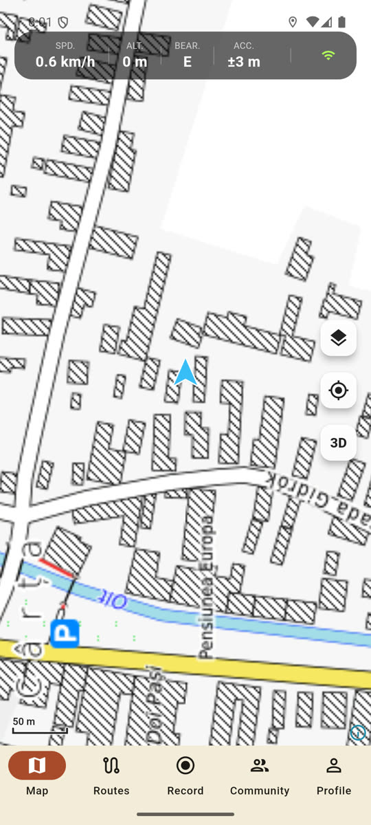
The top data strip (HUD)
A black rounded strip runs across the top centre of the map. Left to right:
| Label | What it shows |
|---|---|
| SPD. | current speed in km/h |
| ALT. | altitude above sea level in metres |
| BEAR. | the compass direction you are facing (N, NE, E…) |
| PTS. | GPS accuracy in metres — the smaller the number, the better the fix |
| wifi icon | green = online, red crossed out = offline mode |
While you are navigating, BEAR. is replaced by DIST. in green: how many km are left to the destination.
The strip hides itself during planning, navigation and downloading, so it never covers those toolbars.
The buttons on the right edge
Stacked vertically, at mid-screen height:
- Map Layers (layers icon) — switch the base map, offline maps, legend. See below.
- My location (crosshair icon) — the map jumps to your position and follows it from then on. If you grab and drag the map, following switches off; tap this button again to re-engage it.
- 3D — the 3D view (tilt + relief) toggle. When it is on the button turns orange, the camera tilts and the terrain is rendered.
- Compass — the North up toggle. Orange keeps north at the top; white lets the map turn with your heading. Applies to the phone, Android Auto and CarPlay at the same time.
- Convoy view — only appears while you are in a convoy.
- Weather alert icon — only appears when there is a live alert nearby.
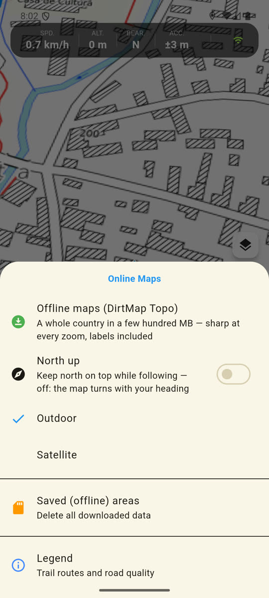
The layers sheet
Tapping the layers button slides a sheet up from the bottom, headed Online Maps. It contains:
- Offline maps (DirtMap Topo) — download a whole country as a vector map.
- The list of base maps: Satellite, Outdoor (plus your own sources if your account is allowed them). A check mark sits in front of the active one.
- Saved (offline) areas, Legend, Tour Routes Layer.
The bottom navigation bar — five tabs
- Map — the map itself. The phone’s Back button always returns here.
- Routes — Navigate (address or map point), My Routes, Planning, GPX Upload, My shares, and under Explore the Peak finder (AR).
- Record — Track recording, Record area, Daily Recordings. While a recording runs, the tab icon glows red.
- Community — Convoy and Competition Center. A green dot at the end of a row means that one is active.
- Profile — your name, Edit Profile, Car Fleet, OBD-II, Logout, and the version number at the very bottom.
The bottom bar deliberately disappears during planning, navigation, offline download and drawing — those modes bring their own toolbars. Finish or cancel the mode and the bar comes back.
6. Choose your language
The app speaks four languages: English, Hungarian, Romanian, German.
- Tap the Profile tab.
- Tap Edit Profile.
- Scroll down to the Settings section.
- Open the dropdown on the right of the Language row and pick English, Hungarian, Romanian or German.
The interface switches immediately — no restart needed — and the choice is remembered for the next launch.
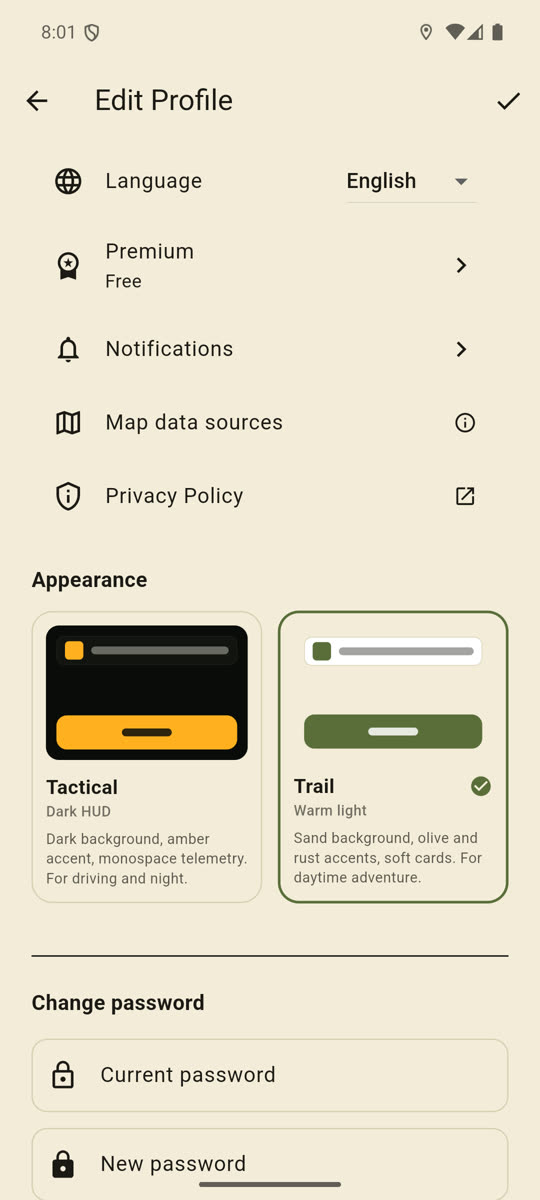
7. Day and night appearance
Further down the same screen, the Appearance section holds two cards side by side:
- Tactical — Dark HUD: dark background, amber accent, monospace telemetry. For driving and night.
- Trail — Warm light: sand background, olive and rust accents, soft cards. For daytime adventure.
Tap the card you want; the theme changes across the whole app immediately and survives a restart. On a fresh install Trail (the light one) is the default.
The app does not switch automatically at sunset — you flip it yourself.
If something goes wrong
“Invalid email or password. Please check your credentials.” A typo in the address or the password. If you cannot remember it, use the Forgot password? link.
“Network error. Please check your internet connection.” Signing in and registering need internet — this one step cannot be done offline. Once you have signed in on this phone at least once, the app starts without internet next time using the cached profile.
“GPS ERROR: Location is turned off!” Location is switched off on the phone itself. The Settings button in the message takes you straight to the system location settings.
“Location permission denied — enable it in Settings.” You declined the permission earlier. The Settings button opens the app’s system settings. On iPhone the app only ever asks once, so this is the only way back.
I tap the locate button and nothing happens. There is no GPS fix yet. Get out from under cover and wait 10–30 seconds; until then the PTS. field shows a large number or nothing.
I declined the Location data use dialog. Then the app never asked the system either. The dialog comes back the next time you start the app — choose Continue there.
The orange “Please verify your email address!” bar will not go away. Open the email and click the link. If it did not arrive, check your spam folder, then tap Resend.
I want to log out as a guest. The app asks first: Log out as guest? — because you cannot sign back into a guest session, and your convoys, results and routes would be lost. Three choices: Cancel, Log out anyway (final), or Create account (everything is kept).
A paywall pops up on a feature. The free account’s limits are: 3 downloaded offline areas, 15 routes saved to the cloud, and your own convoy holds up to 4 riders. Beyond that you need Premium — this is not a fault.
The bottom tab bar has disappeared. You are in planning, navigation, offline download or drawing mode. Finish or cancel that mode from its own toolbar and the bar comes back.